ANCHORAGE: The Anchorage basin holds over 35% of the
population of the state. It lies at the
tip of the Cook Inlet and is Alaska's largest seaport - hence the name of the
city (again, by vote of the people).
Since Anchorage is just above the Kenai Peninsula, it did not go
unscathed by the 1964 earthquake. Recall
that Valdez went down and Seward went up?
Well … Anchorage went out. Land
on Anchorage's southeast shore was pulled out to sea: some two miles. Since the stability of that new land was dubious,
they dubbed it as a wildlife preserve and fenced it off so no-one could build
on it. However, they did build a road
out there. The photo below was taken from a point that would have been in the
town when I graduated from High School.
It is now two-miles sea-ward.
L1-D3533 Sue & Jer pull
Anchorage from a hat

Alaska has more private pilots per capita
than any state in the nation. There are
few highways in Alaska and there is generally only one way to get from point A
to point B. The use of small aircraft
makes commuting over the sometimes enormous distances between those A's and
B's possible. It also makes possible delivery of emergency
supplies to remote areas and opens up much of the country for hunting and
fishing. Most large cities have lagoons
adjacent to their airports expressly for these pontoon boats. Many of them are outfitted so they can switch
landing gear from pontoons, to skis, to tires for runway landings or to big
balloon tires to land on the snow.
Anchorage has the largest small aircraft airport in the world. The waiting list for sites on the lagoon is
measured in decades.
L2-i3642 Pontoon planes at Anchorage
Airport annex

Anchorage is a typical big
city. Citizens live here year-round in
fairly moderate temperature; highs averaging 60-degreees in summer and 30-deg
in winter. They have theatre, movies,
museums and office towers. Though
tourism is a minor part of their economy, there are lots of things for visitors
to do … and we did many. Saw the world's
tallest chocolate fountain, visited the ULU knife factory, rambled thru the
weekend market place.
L3-i0468: Anchorage 1st Friday
Marketplace.

… Bottom line, what can you say
about a town in "the last
frontier" where our RV Park was directly across the street from
Costco?
DENALI:
Denali is not so much a town as a
region. The town lies just outside the
Denali National Wildlife Preserve which encompasses Mt McKinley/Denali as part of
the highest mountain range in the US.
Denali sits on the Nenana River that flows at some 30,000 gallons per
minute up toward the Yukon River. Denali
has two hotels, 2 RV parks and a double handfull of busses bringing tourists to
the town every day. Inside the Park
there is a railroad stop, another hotel and significant camping facilities. The town is open four months of the year and
commerce completely shuts down for the eight months of winter.
On a very clear day, you can see Mt
McKinley from Anchorage. We got our
first glimpse of Mt McKinley at a roadside stop about half way to Denali. That's it, hiding behind the cloud above the
tall spruce on the left.
L4-D3547 Alaska Range, behind
Fireweed

The magenta flower in the foreground
is fireweed. It is the state flower and has some unique behavior. Fireweed is the first flowering plant to grow
in an area besieged by forest fire. They
also tend to line the roadside in the cleared area between the road and the forest. Fireweed blossoms first appear just above the
leafy part of the stem (seen on the flower at the lower left). Blossoms appear above that as these first
blooms deflower, forming a wave of color that progresses up the frond as summer
progresses (see second from left). At
the end of the summer, the blossoms all disappear and the whole plant begins to
turn white. It is understood that white
fireweed indicates that snow will come in six weeks.
The Denali National Wildlife
Preserve is the third largest in the world and the second largest in the state. It covers some 10,000 square miles with no
houses, buildings, or roads. Man may
only visit Wildlife preserves and can do nothing that would affect the balance
of nature. Hikers may camp, but must
return per their posted 'flight-plan'. There
is one 65-mile long road that goes about half-way into the preserve, but it is
not paved, and there are no fences. The
road is not legally in the preserve since the park boundary has been
gerrymandered to exclude the roadway and it's graded shoulders. This is the road from which bicyclers and our
tour (with about 15 to 20 more busses each day) get to view the wildlife in
that sanctuary.
Our first sighting was a caribou -
at rest.
L5a-D3557 A typical Caribou sighting

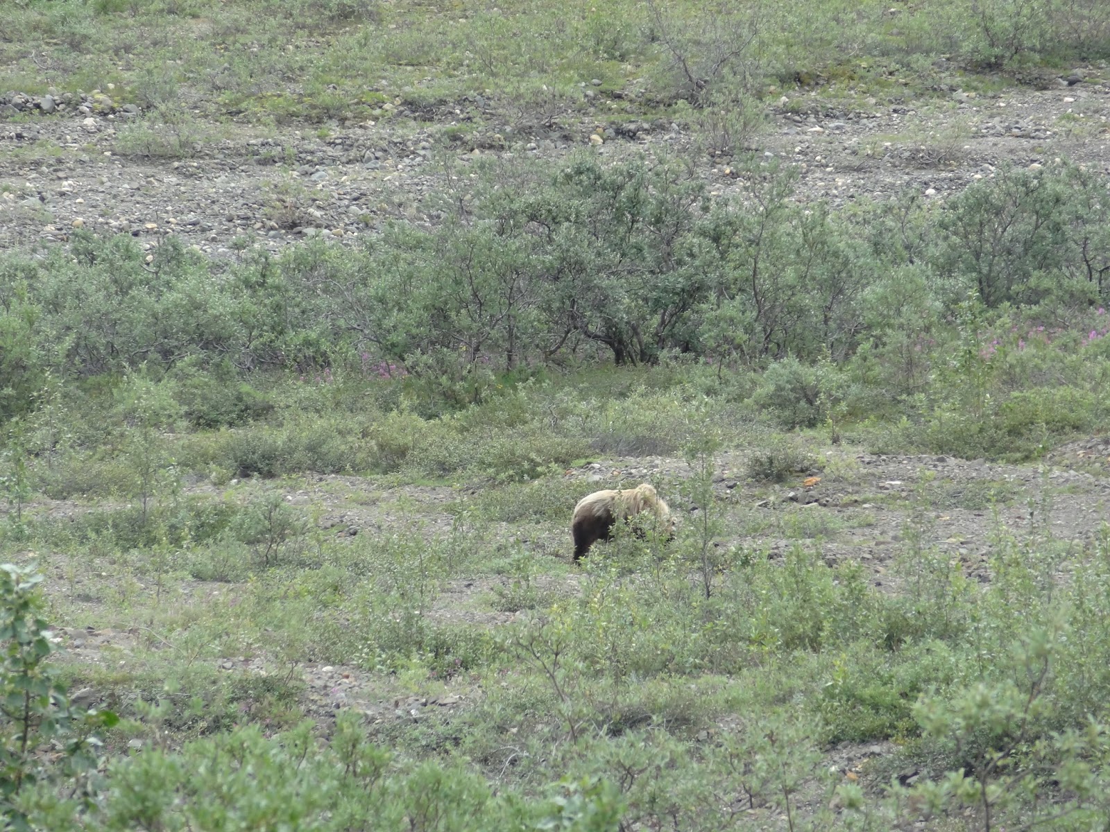
Second animal sighted was a grizzly
and her pup. This view of the grizzly mom took the full
power of my 16x lens.
L5b-D3586 Grizzly from a respectful
distance
The cub was frolicking on the other
side of the creek from mom. I had a
clear shot snapped him, but you'd have to project my photo onto a 40-foot high
screen to get him lifesize. Nobody
should hope to photograph wildlife with anything less than a 200x. You can pop these shots open on your device to expand them.
L5bb-D3584 Frolicking cub

L5c-D3567 Caribou King of the Hill

Later, we did see a small herd; near
enough to get a reasonable shot.
L5d-D3568 Closer to the Caribou

At the end of our 65 mile journey
into the sanctuary, we paused to gaze upon Mt McKinley from the closest point
of our entire journey. The driver warned
us that from there, the peak was behind clouds 90% of the time. He provided us with a photo of what it looked
like the other 10% of the time.
L5e- D3596 90% and 10% shots of Mt McKinley/Denali

Treeline in the park is about
2500-feet. Treeline at this low elevation
is not a result of a poor oxygen supply, but is caused by the short length of
the growing season - suppressing even the highly adapted Sitka spruce. Fireweed even peters out up here. Moss and small, creeping shrubs make up most
of the vegetation atop the permafrost crust of the earth.
Permafrost is not a plant or collection of plants, but a region in which
the ground, at some point below the surface, never thaws. This subsurface (permafrost) material is a
combination of vegetation, dirt, and water and at some point every year,
freezes all the way up to the surface.
The shot below shows some of that structure, with mossy plants on a thin
layer of topsoil and the layer loamy earth below that continues down thru the
point where the water in the soil crystalizes into ice.
L5f-D3598 Moss atop the Permafrost, at above 2500' tree-line

So all this beauteous nature draws
throngs of adventurous people to Denali.
And where there are adventurous people, adventures break out. Did I mention the fast-flowing Nenana river? Perfect for kayak and raft rentals as a
diversion from all those gift shops.
Here is Susie and me with our friends the Coveys, decked out in
'drysuits', just before we entered the rapids.
In the later shots we were offered, one or all of us were obscured by
waves or over-splash as we pounded into a trough.
L6-i0473 StCrains and Coveys rafting
the Nenana.

The next shot is perhaps the most
unexpected of all in this natural paradise.
There is a 15-square mile carve-out in the upper right-hand corner of
the preserve with an active mine. Since
it was not …"untrammeled by man" it could not qualify for
inclusion. That left it open to
commerce. Why not rent the adventurers
an ATV? Yes friends, here we see ---
L7-D3605 Susie with her 4-wheeled
ATV

We made two more attempts to see an
unobscured Mt McKinley, by driving out to the observation pull-out at
the13-mile point.. On the first of these,
it was business as usual. But, on the
way back, we found a moose cow and her two cubs dining on the fireweed at the
edge of the road.
L8a-D3609 Moose cow with two calves,
peeking thru fireweed

The next morning, we awoke to an
overcast sky. However, as we prepared to
load the Prius back onto the dolly and leave, it began to look like it might
clear up. So, decided to make one last
run to the 13-mile point. Voila
L8b-D3616 Gotcha Denali

I want to end with one last
observation of Denali. The first
immigrants to this region, some 1200 years ago, named this mountain Denali - "the high one", or "the tall one". That name continued in usage by the
people of the First Nation and by later immigrants: until 1901 when it was
renamed to honor the recently assassinated president McKinley - not our tallest
president. In 2001, Alaska made a formal
request to have the local name re-instated, because of strong regional
sentiment. The red-tape that has kept
the question from the required congressional vote…"Stalemate".
L8c-D3550 Mt McKinley or Denali?

We're over half-way into the tour at this
point.
431 Trip Miles: 3100 to 3568 …
L9-i0468 Homer-Anchorage-Denali

No comments:
Post a Comment