Sunday, August 16, 2015

N: Above the ARCTIC CIRCLE: Coldfoot to Wiseman


The Dalton Highway is the only road to the North Shore of Alaska.  It runs 500-miles from Fairbanks to Prudhoe Bay.  There is one restaurant/truck stop/air-field in the center of that stretch: Coldfoot, Alaska.  Even more amazing is the community of Wiseman (pronounced Weiss-man). It is the only active community along the Dalton as it winds between national parks and the Brooks Mountains.  Wiseman is some 15 miles north of Coldfoot and sixty miles above the Arctic Circle.  Gold was discovered there in 1892, although there is no active mining in the Preserve today.  Seven of us Fantasy RV-ers flew up to see what life was like above the Arctic Circle.
N1-D3751 Flight Path 

The Alaska Pipeline follows Dawson Road from the north shore of Alaska to Fairbanks.  The design and maintenance of this pipeline to be compatible with continuously moving earth above the permafrost, to be non-interfering with the movement of wildlife and to protect the environment is an engineering masterpiece.
N2a-D3742 Pump Station emerging from the wing (my best shot)

We were able to observe a number of important features of this land on the flights up and back.  Forest Fires are an important part of the ecological life cycle in the arctic.  Up here, they are started by lightning (not man) and are allowed to burn naturally within the Preserve.  While we were up, there were seven fires at various stages of activity.
N2b-D3756 Smoke from some of the half-dozen on-going forest fires in AK

The Yukon River travels 1996 miles to the Arctic Sea.  This published number (1996) was probably wrong the minute it was written down.  The river is continually changing course, exemplified by the wide range of lakes and streams surrounding it as it widens and slowly changes its course.
N2c-D3758 Meandering Yukon River

The only bridge over this river in its entire 2000-mi stretch appears along-side the Alaska Pipeline.  Unfortunately, I was not able to get a clear shot of it, but both crossings are at a narrow region of the Yukon, just below the Arctic Circle.
N2d-D3779 the Pipeline (trust me, it crosses the Yukon above ground)

We were told that Fireweed is the first flowering plant to backfill the burned areas of the forest.  Our prior experience was that fireweed grew in the cleared areas along the roadsides. From the air, one gets a true impression of the proliferation of Fireweed in nature.   Numerous Fireweed beds, ten to a-hundred square miles in expanse can be seen.
N2e-D3818 Fireweed begins to fill fire ravaged area nominally 2-years after the burn

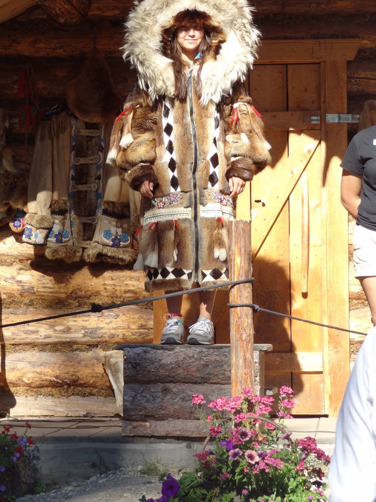
Coldfoot began as an informal stopping place for truckers.  After years of operation, the Government voted to allow one commercial operation at this midway point, predicated on that promise that a particularly popular musher, and multiple winner of the Iditarod be its proprietor.  Many of the materials for building the cafe were provided by the truckers who used it, freeloading the materials and dropping them off as they stopped by.  Prominent in the restaurant is the "Message Pole" they would (and still do) use to update their colleagues.
N3-I3667 Cold Foot Message Pole

The town of Wiseman is still vital with about half a dozen sourdough families and a few seasonal miners and trappers.  
N4a-D3792 Wiseman Welcome Sign 

We were driven to Wiseman by a recent Zoology graduate who was working in Alaska to hike and camp and pay off her student loans.  She is shown here beside the local resident who told us about the ecology and wildlife of the area.  He, his wife and 2-year old daughter live off the land year around.  He traps, fishes and hunts for game and livelihood.  They have generators and bottled gas, but their food comes from vegetable gardening and hunting.
N4b-D3796 Guides Resident Sourdough and Graduate Zoologist

He moved there with his dad as a young boy and was there to see the changes brought on by the road and the pipeline.  In fact, he is on the boards of the Pipeline and a couple of oil companies as a consultant on ecological impact of their system.  
N4c-D3798 One of the original cabins w/3rd roof (& solar panels added at the back)

We took a short walk thru the village to see some of the original buildings/dwellings that are still used and maintained today.  Residences have cellars in which to store vegetables year round.  One buildings has been set-aside as a sort of museum with photos of life in the north, examples of animal pelts and by-products, and geological specimens.  
N4d-D3799 Welcome Center and Museum

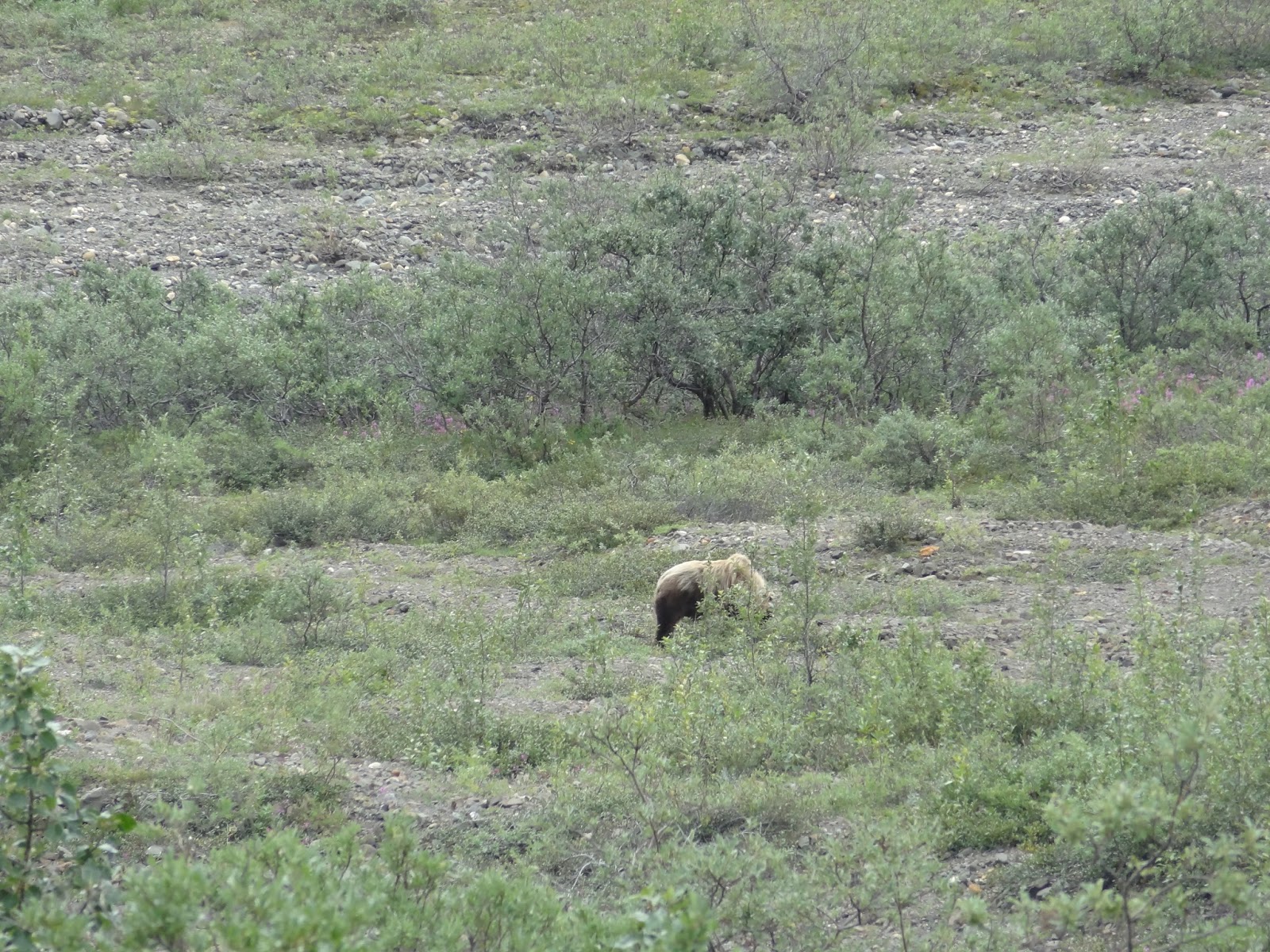
Shown below is a typical house,  built close to the ground with thick log walls for warmth.  Just in front of the house is a snow-shoe rabbit: a summer garden invader and year-round resident.  For protection from predators, their coats are brown in the summer and white in the winter.  Our attendant Zoologist informed us that the snowshoe is a fecalvore.  That is, in the wintertime, their diet is woody plants and other matter that is difficult to digest in a single pass.  Their special technique to get all the food energy from this diet is to run it thru a second time.  They don't regurgitate the food to do this … thus the term.
N4e-D3797 Wiseman scene, showing the uniquely adapted snowshoe rabbit.

There is yet another invader to these bucolic environs.  One such is shown below
N4f-D3800 Crain was here.

Trip Miles: 265 air-miles along the Dalton Highway (a Road not Taken)
N5-i0467 Fairbanks to Wiseman - Flown not Driven


Saturday, August 15, 2015

M: Fairbanks


FAIRBANKS:  Did mostly touristy stuff in Fairbanks, but enjoyed them.  We got a glimpse of how life was in the early years - from the 9th century First Nations emigration - to the 19th century gold rush - to the 20th century growth of infrastructure in the 'last frontier'.
Fairbanks is the closest large city to the Arctic Circle (160 miles south of Latitude 66-deg 33 min).  Major growth came with the gold rush and other mining followed by Defense with large Army and Air Force bases.  The Pipeline comes straight down from Prudhoe Bay, thru Fairbanks, and then on to Valdez.  Fairbanks does have navigable rivers that connect to the Pacific, but not year around.  The population of about 32000 is a hardy bunch that keeps the town open year round: despite winters that stay below minus forty degrees (F) for weeks at a time.  We are reminded that it's a very dry -40°; here's Susie and me, standing in a locker in that dry climate:
M1-40Below:  Sue and I improperly clad for a Dry minus forty-Fahrenheit

We took a paddle-wheel boat up the Chena river that hit on 9th and 20th century activities.  The paddleboat Discovery II was captained by the fully qualified and licensed granddaughter of the couple who founded this venture.
M2a-D3680: Paddle-Wheel boat up the Chena River

Recall that small aircraft have a lot to do with keeping the far reaches of this state in contact with civilization (think Wiley Post).  Right off the bat, a Pontoon plane took-off, circled, and landed right next to our boat.
M2b-D3630: Pontoon plane takes off and lands in 100-yards of Chena River

Up on the river bank, we got to see a team of 16 huskies get hooked to and run out and back on about a half-mile run, pulling a 4-wheeled ATV at up to 30 mph.  More on this later when we talk about Muktuk.
M2c-i2574 Susie's shot of the husky team.

The riverboat stopped at a simulated Athabascan village where we learned about the lore and tolls of the First Nation peoples who lived along the river.  Hunting and fishing provided much of their livelihood and life support.  Salmon, both those who live here during the first two to three years of their life, and those large fish who run up the Chena to spawn were caught with nets, filleted and put on drying racks before they were taken to a smoke-house for final preservation.
M2d-D3647 An Athabascan student filets fish to hang in Drying Rack/Smoke House

Reindeer are (near-) domesticated relatives of the caribou.  They share the same foot shape as the caribou, whose name is the native word for 'shovels for feet'.  The antlers, hides, meat and bones of these deer each served a purpose in the life of these early settlers.
M2e-i2591 Reindeer, related to the caribou, share the same "Shovel Feet" 

Athabascans developed log houses and outbuildings.  They trapped beaver, ermine, fox and larger animals to provide clothing to protect them from the elements (cold).  Hides from four different animals were used to fashion this full-length coat.  The function is ancient, the style of adding beadery is an 18th century adaptation.
M2f-D3660 Athabasca Winter Coat

Fairbanks hosts an annual ice-carving competition each March.  Statues are carved from either single blocks 6'x4'x3' or from multiple of these blocks for larger structures.  Tools are unlimited and include chain saws, chisels, blow torches, drills and other inventions.  Selected of each year's entries are kept in the downtown Ice Museum, open to the public
M3a-D3604 Small Ice Sculpture entry

The curator carved this 'inverted image' of a flower for us in about 15 minutes using a hand drill, a Dremel and a blowtorch.
M3b-D3705 Ice Carving while you wait- also 3703

The Fountainhead Automobile Museum has a collection of some 193 restored from the era before WWII.  Below, without comment are some of my favorites from the turn of the century to the start of the Great Depression.  Evolution: cylinders from 2 to 12; horsepower from 10 to 100, styles from buckboard to saloon cars/sportsters/convertibles/limousines; and power from steam and electric to gasoline.  Purchase prices ranged from under $100 at the turn of the century to $3,000 to $15,000 (then-year dollars) just before the great depression.
M4a-D3717 1907 Ford

M4b-D3709 1912 Premier


M4c-D3712 1932 Cadillac

M4d-D3724 1933 Hupmobile

M4e-D3728 1933 Auburn


M4f-D3720 1933 Cord


Dang, I love Nature … human nature, that is.
Gold is big in Fairbanks too.  Shown is one of the several dredge, strip, and placer mining sites around the town.  
M5a-D3728 Dredge Mining at Fairbanks

In Fairbanks, we also visited the Tanna Valley gold mine where we saw even more ways that miners extracted paydirt from the ground and processed gold from these stockpiles of earth.  Bottom line, gold is in the mud on the rocks, you've got to use it's 20x weight differential to separate it out.  The old fashioned gold pan is slow, but effective.  Here's Susie's take from a bag of pay-dirt about as big as a bag of jelly beans.
M5b-i2614 Susie's Gold Pan (This trove can now be worn in a locket)

Muktuk:  Just outside Fairbanks, we met another, unique entrepreneur at the MucTuc Kennels (muktuk.com).  Muktuk Adventures and Kennels was begun by Mr Frank Turner and his wife Anne Tayler in 1995.  Frank was/is one of the top ''Mushers" in Alaska, competing in the Yukon Quest 24 times and winning one of those.  Muctuk kennel remains very active in the two top competitive dog-sled racing events in Alaska, the Iditerod and the Yukon Quest each year.  They breed and keep a stock of about 100 competitive dogs plus a double handful of retirees who live out their waning years with them.  During our visit, Ms Manuela Albicker gave us a terrific rundown of the husky-dog lineage and competitive dog-sled racing.  MukTuk offers training/instructive outings of up to 4-weeks to prospective mushers.  This helps defray the $30K cost of competing in each major racing event.
M6a-i2618 MukTuk signpost near the lodge.

Huskies are not a "Purebred" dog strain.  To be a Husky, the only requirement is that the dog have direct lineage to the dogs domesticated by the First Nation peoples who traveled to Alaska with them some 1200 years ago.  Each kennel crossbreeds their stock with other breeds to emphasize specific traits (coon-dogs for stamina, greyhounds for speed, yorkies for ??).  The most noticeable trait of these dogs is - they love to run!  For those of us who visualize Simon Lagree using a whip to urge his dogs on … re-think.  Basically, the musher's job is to slow them down enough to steer them, and/or hold on for dear life - they will leave you if you don't keep up!
M6b-i0474: Dogs of MukTuk - I apologize for stealing from their website - We've lost nearly all of our photos from this visit (iPhoto to Photos issue?)

Manuela Albicker is a musher whose stories of training and racing dogs were vivid.  Want to change your dog's bad behavior ??? bite on it's ear.   She showed us how to get your dog water and food at -40 degrees (F or C).   Shared a few hows and whats to do when racing a thousand miles against a hundred other teams in subzero weather with only a few, pre-determined, 60-pound bags of supplies.  To wit: Keep a cool head; Get into the competition's heads; don't stop at the head.
M6C-i2617 Manuela Albicker: Musher, Entrepreneur.

Manuela got into mushing by accident.  She migrated to Fairbanks from the Black Forest in Germany as a journeyman carpenter.  When she got here, the company was gone.  Perusing the listings at the local Visitors Center, Frank offered her temporary work and a place to stay while she found a job.  Her bio on the "Staff" tab of the web page states, perhaps presciently…"After being with Muktuk for eight year she is ready to take the lead of the four and two-legged pack."  - She now owns the place.
Trip Miles: 3568-3692
M7-i0469 Denali to Fairbanks


Friday, August 7, 2015

L: Homer/Anchorage/Denali


ANCHORAGE:  The Anchorage basin holds over 35% of the population of the state.  It lies at the tip of the Cook Inlet and is Alaska's largest seaport - hence the name of the city (again, by vote of the people).   Since Anchorage is just above the Kenai Peninsula, it did not go unscathed by the 1964 earthquake.  Recall that Valdez went down and Seward went up?  Well … Anchorage went out.  Land on Anchorage's southeast shore was pulled out to sea: some two miles.  Since the stability of that new land was dubious, they dubbed it as a wildlife preserve and fenced it off so no-one could build on it.  However, they did build a road out there. The photo below was taken from a point that would have been in the town when I graduated from High School.  It is now two-miles sea-ward.
L1-D3533 Sue & Jer pull Anchorage from a hat

Alaska has more private pilots per capita than any state in the nation.  There are few highways in Alaska and there is generally only one way to get from point A to point B.  The use of small aircraft makes commuting over the sometimes enormous distances between those A's and B's possible.  It also makes possible delivery of emergency supplies to remote areas and opens up much of the country for hunting and fishing.  Most large cities have lagoons adjacent to their airports expressly for these pontoon boats.  Many of them are outfitted so they can switch landing gear from pontoons, to skis, to tires for runway landings or to big balloon tires to land on the snow.  Anchorage has the largest small aircraft airport in the world.  The waiting list for sites on the lagoon is measured in decades.
L2-i3642 Pontoon planes at Anchorage Airport annex

Anchorage is a typical big city.  Citizens live here year-round in fairly moderate temperature; highs averaging 60-degreees in summer and 30-deg in winter.  They have theatre, movies, museums and office towers.  Though tourism is a minor part of their economy, there are lots of things for visitors to do … and we did many.  Saw the world's tallest chocolate fountain, visited the ULU knife factory, rambled thru the weekend market place.
L3-i0468:  Anchorage 1st Friday Marketplace.

… Bottom line, what can you say about a town in "the last frontier" where our RV Park was directly across the street from Costco?
DENALI:   
Denali is not so much a town as a region.  The town lies just outside the Denali National Wildlife Preserve which encompasses Mt McKinley/Denali as part of the highest mountain range in the US.  Denali sits on the Nenana River that flows at some 30,000 gallons per minute up toward the Yukon River.  Denali has two hotels, 2 RV parks and a double handfull of busses bringing tourists to the town every day.  Inside the Park there is a railroad stop, another hotel and significant camping facilities.  The town is open four months of the year and commerce completely shuts down for the eight months of winter.
On a very clear day, you can see Mt McKinley from Anchorage.  We got our first glimpse of Mt McKinley at a roadside stop about half way to Denali.  That's it, hiding behind the cloud above the tall spruce on the left. 
L4-D3547 Alaska Range, behind Fireweed

The magenta flower in the foreground is fireweed. It is the state flower and has some unique behavior.  Fireweed is the first flowering plant to grow in an area besieged by forest fire.  They also tend to line the roadside in the cleared area between the road and the forest.  Fireweed blossoms first appear just above the leafy part of the stem (seen on the flower at the lower left).  Blossoms appear above that as these first blooms deflower, forming a wave of color that progresses up the frond as summer progresses (see second from left).  At the end of the summer, the blossoms all disappear and the whole plant begins to turn white.  It is understood that white fireweed indicates that snow will come in six weeks.
The Denali National Wildlife Preserve is the third largest in the world and the second largest in the state.  It covers some 10,000 square miles with no houses, buildings, or roads.  Man may only visit Wildlife preserves and can do nothing that would affect the balance of nature.  Hikers may camp, but must return per their posted 'flight-plan'.  There is one 65-mile long road that goes about half-way into the preserve, but it is not paved, and there are no fences.  The road is not legally in the preserve since the park boundary has been gerrymandered to exclude the roadway and it's graded shoulders.  This is the road from which bicyclers and our tour (with about 15 to 20 more busses each day) get to view the wildlife in that sanctuary.
Our first sighting was a caribou - at rest. 
L5a-D3557  A typical Caribou sighting

Second animal sighted was a grizzly and her pup.   This view of the grizzly mom took the full power of my 16x lens. 
L5b-D3586 Grizzly from a respectful distance

The cub was frolicking on the other side of the creek from mom.  I had a clear shot snapped him, but you'd have to project my photo onto a 40-foot high screen to get him lifesize.  Nobody should hope to photograph wildlife with anything less than a 200x.  You can pop these shots open on your device to expand them.
L5bb-D3584 Frolicking cub


Fortunately,  at the next curve, we caught sight of another caribou bull overseeing his herd.  Unfortunately, the herd was on the other side of the ridge …
L5c-D3567 Caribou King of the Hill
Later, we did see a small herd; near enough to get a reasonable shot.
L5d-D3568 Closer to the Caribou
At the end of our 65 mile journey into the sanctuary, we paused to gaze upon Mt McKinley from the closest point of our entire journey.  The driver warned us that from there, the peak was behind clouds 90% of the time.  He provided us with a photo of what it looked like the other 10% of the time.
L5e- D3596 90% and 10% shots of Mt McKinley/Denali

Treeline in the park is about 2500-feet.  Treeline at this low elevation is not a result of a poor oxygen supply, but is caused by the short length of the growing season - suppressing even the highly adapted Sitka spruce.  Fireweed even peters out up here.  Moss and small, creeping shrubs make up most of the vegetation atop the permafrost crust of the earth.  Permafrost is not a plant or collection of plants, but a region in which the ground, at some point below the surface, never thaws.  This subsurface (permafrost) material is a combination of vegetation, dirt, and water and at some point every year, freezes all the way up to the surface.  The shot below shows some of that structure, with mossy plants on a thin layer of topsoil and the layer loamy earth below that continues down thru the point where the water in the soil crystalizes into ice.
L5f-D3598 Moss atop the Permafrost, at above 2500' tree-line

So all this beauteous nature draws throngs of adventurous people to Denali.  And where there are adventurous people, adventures break out.  Did I mention the fast-flowing Nenana river?  Perfect for kayak and raft rentals as a diversion from all those gift shops.  Here is Susie and me with our friends the Coveys, decked out in 'drysuits', just before we entered the rapids.  In the later shots we were offered, one or all of us were obscured by waves or over-splash as we pounded into a trough. 
L6-i0473 StCrains and Coveys rafting the Nenana.

The next shot is perhaps the most unexpected of all in this natural paradise.  There is a 15-square mile carve-out in the upper right-hand corner of the preserve with an active mine.  Since it was not …"untrammeled by man" it could not qualify for inclusion.  That left it open to commerce.  Why not rent the adventurers an ATV?  Yes friends, here we see ---
L7-D3605 Susie with her 4-wheeled ATV

We made two more attempts to see an unobscured Mt McKinley, by driving out to the observation pull-out at the13-mile point..  On the first of these, it was business as usual.  But, on the way back, we found a moose cow and her two cubs dining on the fireweed at the edge of the road. 
L8a-D3609 Moose cow with two calves, peeking thru fireweed

The next morning, we awoke to an overcast sky.  However, as we prepared to load the Prius back onto the dolly and leave, it began to look like it might clear up.  So, decided to make one last run to the 13-mile point.  Voila
L8b-D3616 Gotcha Denali

I want to end with one last observation of Denali.  The first immigrants to this region, some 1200 years ago, named this mountain Denali - "the high one", or "the tall one".  That name continued in usage by the people of the First Nation and by later immigrants: until 1901 when it was renamed to honor the recently assassinated president McKinley - not our tallest president.  In 2001, Alaska made a formal request to have the local name re-instated, because of strong regional sentiment.  The red-tape that has kept the question from the required congressional vote…"Stalemate".
L8c-D3550 Mt McKinley or Denali?


We're over half-way into the tour at this point.
431 Trip Miles: 3100 to 3568 …
L9-i0468 Homer-Anchorage-Denali